A journey through time and achievements allows us to glimpse the early steps of Kazakhstan's inventive school, which inspired subsequent generations to make new discoveries.
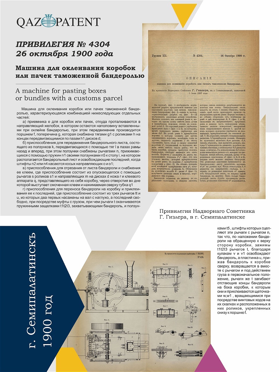
Privy Councillor G. Gisler from the city of Semipalatinsk received a patent for a unique device — a machine for affixing customs labels onto boxes or packages. This invention was an innovative technical solution for automating manual labor, which was particularly relevant at the end of the 19th and the beginning of the 20th century.
The device was designed for the fast and precise labeling of boxes or packages with special customs stamps required for customs control and goods accounting. The machine’s operation involved several sequential actions:
At the turn of the century, Semipalatinsk was not only a transportation hub but also a place where engineering ideas were born and innovative solutions were implemented.
The device was designed for the fast and precise labeling of boxes or packages with special customs stamps required for customs control and goods accounting. The machine’s operation involved several sequential actions:
- Boxes or packages were placed into a receiver and moved to the labeling area by a piston.
- Labels were fed into the machine as whole sheets, which were then cut into strips of the required size.
- Rubber plates ensured precise movement of the sheet, while special mechanisms controlled its even feeding.
- Labels were coated with glue applied via a special sponge to ensure reliable adhesion.
- The prepared label was transferred to the box using levers and spring clamps, and its ends were bent and pressed onto the box using rotating brushes.
At the turn of the century, Semipalatinsk was not only a transportation hub but also a place where engineering ideas were born and innovative solutions were implemented.
City of Semipalatinsk
No. 4304, 1900
No. 4304, 1900
A machine for gluing boxes or packages with customs labels
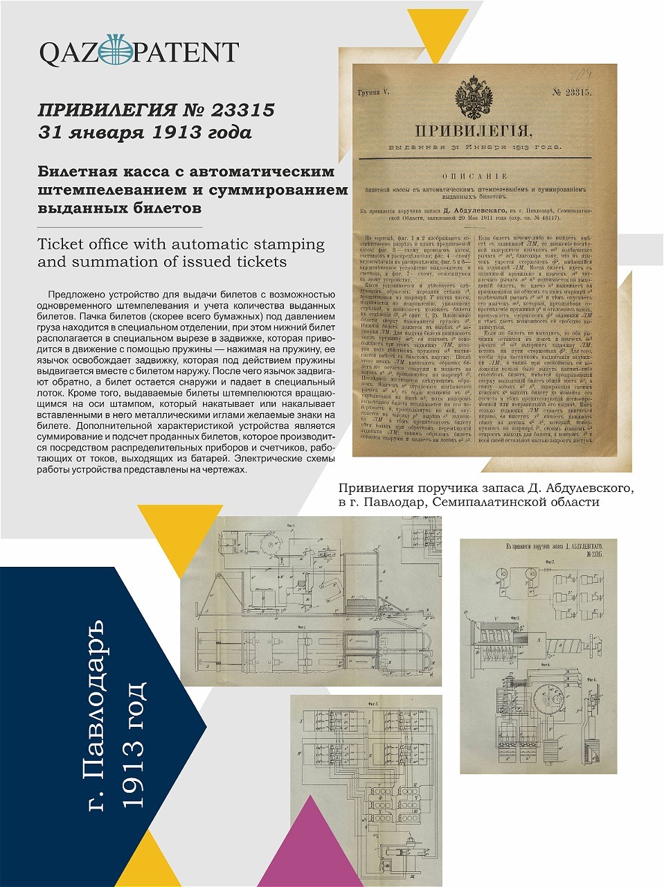
On January 31, 1913, a patent was granted to D. Abdulyevsky, a reserve lieutenant from Pavlodar, Semipalatinsk region, for a unique device that mechanized the ticketing process.
The main feature of the device was its ability to automate ticket issuance, stamping, and accurate counting, making the process faster, more reliable, and error-free. The construction included a spring slider, a system of electromagnets, and mechanical counters. Noteworthy was the automatic rheostat — an innovative component for its time.
This system ensured precise accounting of issued tickets and automatic recording of their number. D. Abdulyevsky's invention represented a significant technological breakthrough, anticipating the mechanization of many ticketing processes. It highlighted the intellectual potential of Kazakhstan's population at the time, their contribution to engineering thought, and their pursuit of innovation.
Today, this unique history inspires a new generation of engineers and inventors, reminding them of Kazakhstan’s proud tradition of innovation and the achievements of their ancestors.
City of Pavlodar
No. 23315, 1913
No. 23315, 1913
Ticket Booth with Automatic Stamping and Summation of Issued Tickets
Все товары

In 1910, the Kemin earthquake, with a magnitude of 7.7, struck Verny, destroying 776 houses, including 94 homes in the Bolshaya Almatinskaya Stanitsa.
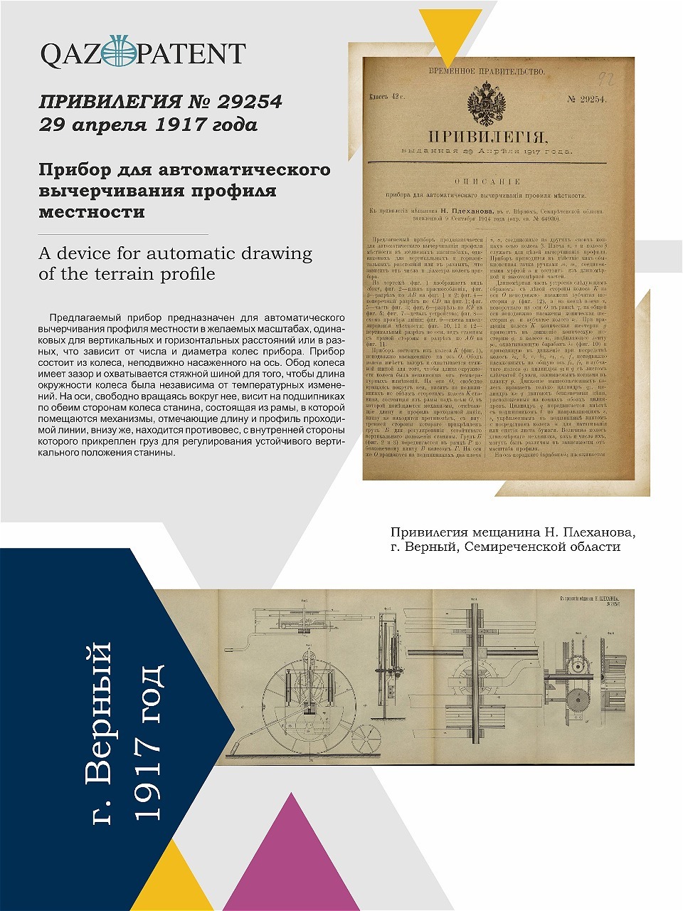
In 1917, N. Plekhanov, a resident of Verny in the Semirechye region, introduced a unique invention — a device for automatically measuring and graphically displaying terrain profiles. It solved several problems: precise measurement of distances, heights, and slopes, with automatic plotting of the obtained data on paper tape. This invention was a breakthrough in geodesy, cartography, and engineering surveys, significantly simplifying labor-intensive processes and ensuring high accuracy of results.
The device consisted of two parts:
Three axes of movement ensured the accuracy and versatility of the work. The device was equipped with an adjustable counterweight for stability on inclined surfaces, maintaining precision even with abrupt changes in terrain.
This invention symbolized the transition from manual labor to automated measurement technologies, enabling specialists to perform their tasks more efficiently and accurately.
In 1917, N. Plekhanov, a resident of Verny in the Semirechye region, introduced a unique invention — a device for automatically measuring and graphically displaying terrain profiles. It solved several problems: precise measurement of distances, heights, and slopes, with automatic plotting of the obtained data on paper tape. This invention was a breakthrough in geodesy, cartography, and engineering surveys, significantly simplifying labor-intensive processes and ensuring high accuracy of results.
The device consisted of two parts:
- A dynamometric section to record measured distances and terrain profiles.
- A drawing section to automatically plot the terrain profile on paper tape.
Three axes of movement ensured the accuracy and versatility of the work. The device was equipped with an adjustable counterweight for stability on inclined surfaces, maintaining precision even with abrupt changes in terrain.
This invention symbolized the transition from manual labor to automated measurement technologies, enabling specialists to perform their tasks more efficiently and accurately.
City of Verny
No. 29254, 1917
No. 29254, 1917
Automatic Device for Plotting Terrain Profiles
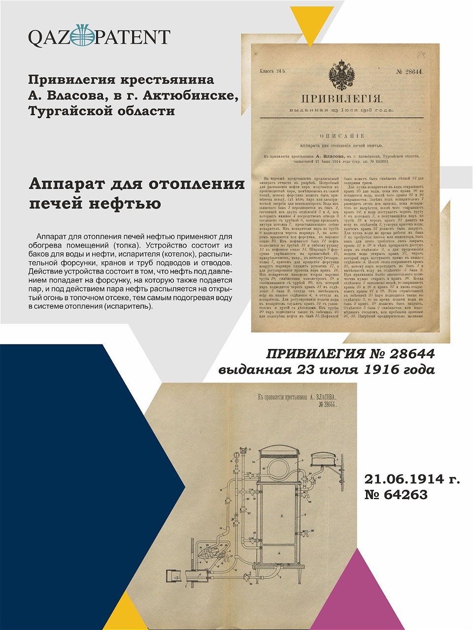
In the early 20th century, amidst the search for alternative fuel sources, A. Vlasov, a farmer from the city of Aktobe in the Turgay region, proposed an innovative solution — a heating apparatus using oil as fuel. For this invention, he received a patent recognizing its significance in advancing heating technologies.
The apparatus allowed oil to be used as a fuel source for heating, offering an economical and efficient solution for household and industrial needs. A key element of the design was a two-chamber water tank that created steam essential for system operation and regulated the supply of oil for optimal combustion. A nozzle in the apparatus sprayed the oil, mixing it with steam. The resulting fuel-steam mixture was efficiently delivered to the furnace, ensuring even and powerful combustion.
At a time when traditional fuels like coal and firewood were expensive and labor-intensive, Vlasov’s invention marked a breakthrough in heating technologies. The use of oil as an alternative fuel source increased efficiency and made heating more accessible for widespread application.
Vlasov's invention was not just a technical solution but a vivid example of a practical approach to solving pressing problems of the time. This apparatus demonstrated how innovative ideas could transform daily life and industry, paving the way for modern energy-efficient technologies.
City of Aktobe
No. 28644, 1916
No. 28644, 1916
Electromagnetic Device for Suspending Rotating Vertical Shafts
Все товары
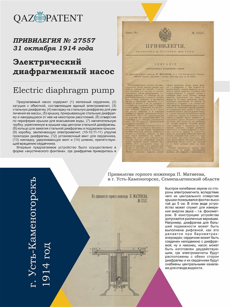
Mining engineer P. Matveev from Ust-Kamenogorsk, Semipalatinsk region, was granted a patent for an invention distinguished by its versatility and precision. The pump could be used for both pumping liquids and measuring sound energy, functioning as an "acoustic fountain," where diaphragm vibrations were generated by sound waves during the pump’s operation with a pulsating direct electric current.
The pump's design was simple and reliable, consisting of an electromagnet, an elastic diaphragm, intake openings, and a discharge tube, making it an efficient and economical solution for technical and scientific purposes. Its uniqueness lay in its ability to operate with high precision at minimal energy costs and adapt to various applications.
Matveev's pump became a striking example of innovation and a pragmatic approach to solving technological challenges at the beginning of the 20th century, opening avenues for further advancements and practical applications in various fields of industry and science.
City of Semipalatinsk
No. 27557, 1914
No. 27557, 1914
Electric Diaphragm Pump
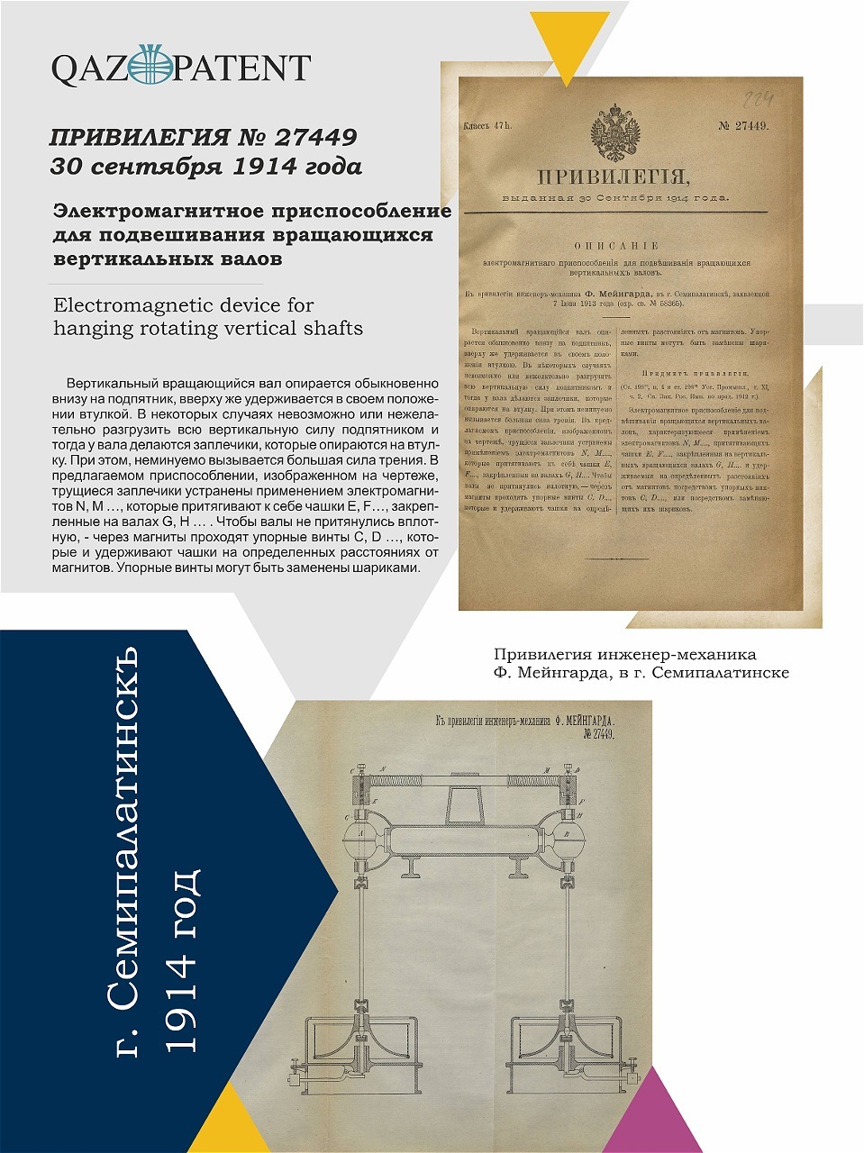
In the early 20th century, as technical progress rapidly transformed the world, mechanical engineer F. Meingard from Semipalatinsk proposed an innovative solution that became a true breakthrough in mechanical engineering. Instead of traditional rubbing supports that caused high friction and rapid wear of mechanisms, Meingard used electromagnets — a bold and progressive technology at the time.
The invention significantly reduced friction, solving several key problems:
Meingard's invention quickly found application in industrial enterprises in Semipalatinsk and beyond. In energy, mechanical engineering, and manufacturing, such solutions were particularly in demand, as the high precision and reliability of vertical shaft mechanisms were crucial for the successful operation of factories and power plants.
The invention significantly reduced friction, solving several key problems:
- Increased the efficiency and reliability of mechanisms.
- Reduced equipment wear, extending its lifespan.
- Provided contactless shaft suspension, marking a significant technological leap.
Meingard's invention quickly found application in industrial enterprises in Semipalatinsk and beyond. In energy, mechanical engineering, and manufacturing, such solutions were particularly in demand, as the high precision and reliability of vertical shaft mechanisms were crucial for the successful operation of factories and power plants.
City of Semipalatinsk
No. 27449, 1914
No. 27449, 1914
Electromagnetic Device for Suspending Rotating Vertical Shafts
Все товары
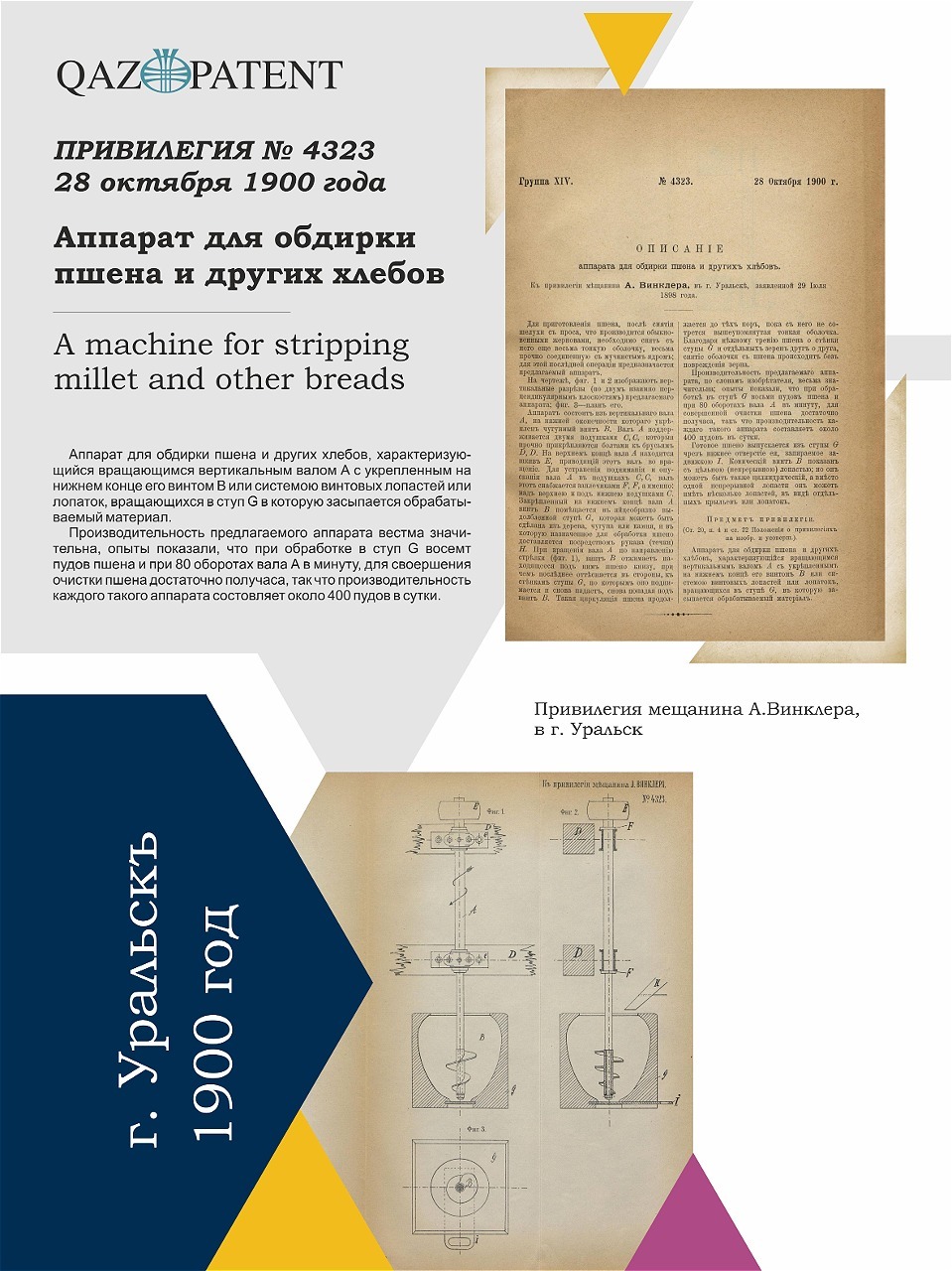
A. Winkler, a resident of Uralsk, received a patent for a unique device for peeling millet and other grains, submitted on July 29, 1898. This invention marked a significant step in mechanizing the agricultural processing of cereals, ensuring more efficient and gentle removal of millet husks.
Preparing millet required removing the outer husk after dehulling, which was tightly attached to the floury core. Manual labor or traditional methods of the time were inefficient and labor-intensive. Winkler's device solved this problem with a mechanical system where the grain was fed into the device via a loading chute and moved downward by a rotating screw. The millet rubbed against the screw and ridges, allowing the husk to be removed without damaging the core due to mild friction and even rotation.
The millet peeling device significantly reduced labor costs and improved the quality of the final product. This invention illustrates how rational and practical solutions supported the development of the agricultural industry, providing the population with more accessible and high-quality food resources.
City of Uralsk
No. 4323, 1900
No. 4323, 1900
Device for Processing Millet and Other Grains
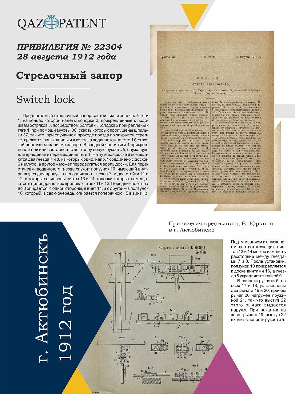
A patent was granted to B. Yurkin, a farmer from the city of Aktobe, for the invention of a rail switch lock. This device became an innovative solution, enabling reliable control of railway switches and preventing accidental failures during track switching.
The operation of railway switches in the early 20th century was a critical task on which the lives and safety of thousands of passengers depended. An incorrect switch position could lead to derailments, delays, and economic losses. Yurkin’s invention addressed this problem with a simple and reliable design that allowed the switch to be regulated and secured with minimal effort.
The core of the device was a pulled switch rod connected to the tip of the rail switch. Using a handle, the switch operator could control the position of the switch, while a system of levers, springs, and locks secured it in the desired position. Importantly, the mechanism could be used in low temperatures and under heavy loads, making it indispensable for Kazakhstan's railways.
In the early 20th century, railways were the lifeblood of the economy, transporting people, goods, and ensuring regional connectivity. Any error in switch operation could result in catastrophic consequences. Thanks to Yurkin’s invention, railway workers gained a reliable tool that improved operational efficiency and, most importantly, ensured safety.
City of Aktobe
No. 22304, 1912
No. 22304, 1912
Rail Switch Lock
Все товары

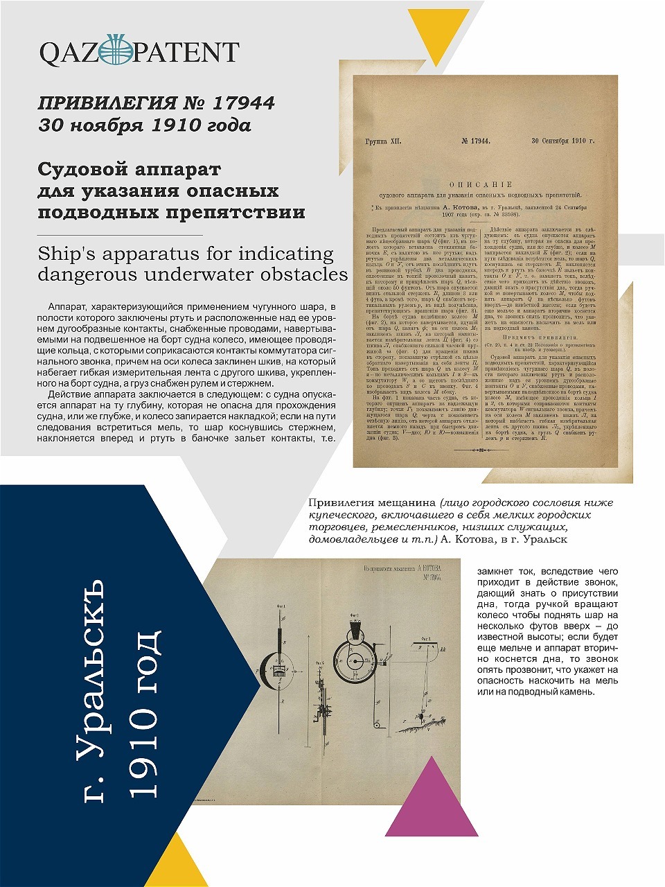
A. Kotov, a resident of Uralsk, was granted a patent for a unique ship apparatus for detecting underwater obstacles, such as shoals, rocks, and other underwater hazards threatening ships.
The apparatus was based on a cast-iron ball (Q), which was lowered to the necessary depth using a steel rod. If an underwater obstacle, such as a shoal or rock, was encountered, the ball tilted, closing electrical contacts. This triggered a bell onboard the ship, warning the captain of the approaching danger. If no obstacles were detected, the ship continued its safe journey without unnecessary risks.
During the navigation season, the Ural River was crowded with ships transporting grain, fish, coal, and construction materials. However, due to poorly mapped channels and the lack of precise charts, ships frequently ran aground or collided with underwater rocks. Within the technical limitations of the time, Kotov created a reliable and effective mechanism that contributed to the development of safer navigation.
City of Uralsk
No. 17944, 1900
No. 17944, 1900
Ship Apparatus for Detecting Underwater Hazards
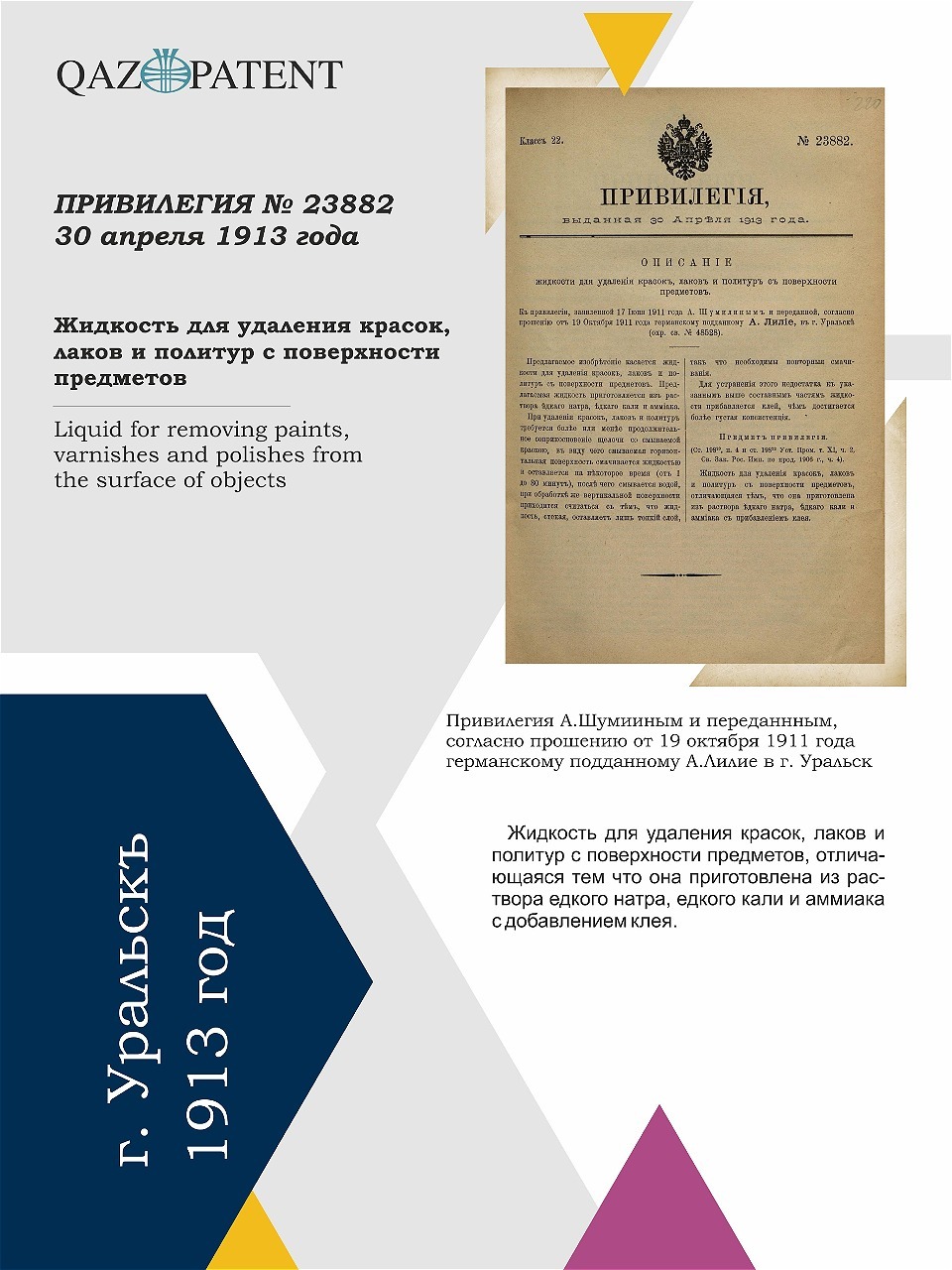
A. Lilie, a German national residing in Uralsk, was granted a patent for a liquid designed to remove paints, lacquers, and varnishes from various surfaces.
The liquid’s composition included alkaline components — caustic soda, potash, and ammonia with added glue. The addition of glue gave the liquid a thicker consistency, particularly important for treating vertical surfaces where ordinary liquids might run off, leaving only a thin layer.
At a time when furniture, doors, and interior items were handmade and decorated with intricate finishes, restoration required days of painstaking labor. Lilie’s invention became a real boon for carpentry workshops, industrial enterprises, and restorers. The liquid not only sped up the process but also improved the quality of cleaning while minimizing damage to the surfaces.
City of Uralsk
No. 23882, 1912
No. 23882, 1912
Liquid for Removing Paints and Lacquers
About the Exhibition
The virtual exhibition opens a window to an era when ordinary people with extraordinary minds created innovations that transformed lives and paved the way to the future. Kazakhstan has always been and continues to be a land of bold ideas, great discoveries, and bright minds whose inventions not only shaped technologies but also contributed to the country’s development, leaving an indelible mark on its history. This is not just a look into the past — it is an invitation to become part of a legacy that continues to live within each of us.
Great achievements always begin with a single bold idea, and this exhibition serves as a reminder: each of us has the opportunity to contribute to history by continuing the traditions of innovation and creation!
Great achievements always begin with a single bold idea, and this exhibition serves as a reminder: each of us has the opportunity to contribute to history by continuing the traditions of innovation and creation!
